Subdivision · Meridian Campus
A separately marketed Rob Rice community within Meridian Campus.
Recorded construction samples:- CAMPUS ESTATES DIV 1: 2015–2016 · 15 year observations · 0.19-acre median residential lot
- CAMPUS ESTATES DIV 3: 2020–2023 · 43 year observations · 0.19-acre median residential lot
- CAMPUS ESTATES DIVISION 2: 2016–2021 · 37 year observations · 0.21-acre median residential lot
Sampled buildings; not a complete buildout history.
Documented builder(s): Rob Rice Homes (marketed brand)
Other builders may also have contributed; not all home and phase records have been reconciled.
Housing history, ownership & sources
- Construction history
- CAMPUS ESTATES DIV 1: 2015–2016 (15 year observations); CAMPUS ESTATES DIV 3: 2020–2023 (43 year observations); CAMPUS ESTATES DIVISION 2: 2016–2021 (37 year observations). Separate recorded groups, not one combined buildout range.
- Housing & styles
- An architectural style is not inferred from a year-built field. Confirm the actual house and original plans.
- Developer
- Rob Rice Homes (marketed brand)
- Homebuilder
- Rob Rice Homes (marketed brand)
- Street examples
- CADDY LN NE · CAMPUS PARK DR NE · CADDYSHACK DR NE · BOGEY DR NE. Sample streets, not a boundary or a matched parcel list.
- Parcel-sample jurisdiction
- Lacey. This reflects the sampled parcels, not every property in the wider browsing region.
- Homebuilder · documented offering
- Rob Rice Homes markets/builds this named community. Applicable recorded divisions, developing legal entity and house-specific permits must be verified; this is not an attribution of every resale house.Source ↗
Other builders may also have contributed; not all home and phase records have been reconciled. The documented attribution applies only to the community, offering or phase identified above.
Recorded names & construction-year samples (3 record groups)
October 10, 2026 research snapshot. These are legal-description search groups, not a count of homes or certified plat boundaries. Divisions, phases and similarly named records remain separate. Year-built fields can include later replacement buildings and non-house property types.
Acreage is the median of positive lot-size observations below 100 acres coded RES in the research, not a measurement of every home lot. Samples can be incomplete or overlap; do not add them to calculate community totals. Confirm the actual parcel, original permit, additions and recorded map before relying on a date or size.
Evidence: community documented. Development dates, association formation and individual home completion are separate facts. Research updated October 10, 2026.
Subdivision · Meridian Campus
A named subdivision near Campus Glen Drive and Willamette Drive.
Recorded construction samples:- CAMPUS GLEN: 2005–2006 · 114 year observations · 0.11-acre median residential lot
- CAMPUS GLEN DIV 2: 2005–2006 · 58 year observations · 0.12-acre median residential lot
Sampled buildings; not a complete buildout history.
Housing history, ownership & sources
- Construction history
- CAMPUS GLEN: 2005–2006 (114 year observations); CAMPUS GLEN DIV 2: 2005–2006 (58 year observations). Separate recorded groups, not one combined buildout range.
- Housing & styles
- An architectural style is not inferred from a year-built field. Confirm the actual house and original plans.
- Homebuilder
- Original builder has not been established in the sources reviewed.
- Street examples
- LANYARD DR NE. Sample streets, not a boundary or a matched parcel list.
- Parcel-sample jurisdiction
- Lacey. This reflects the sampled parcels, not every property in the wider browsing region.
Recorded names & construction-year samples (2 record groups)
October 10, 2026 research snapshot. These are legal-description search groups, not a count of homes or certified plat boundaries. Divisions, phases and similarly named records remain separate. Year-built fields can include later replacement buildings and non-house property types.
Acreage is the median of positive lot-size observations below 100 acres coded RES in the research, not a measurement of every home lot. Samples can be incomplete or overlap; do not add them to calculate community totals. Confirm the actual parcel, original permit, additions and recorded map before relying on a date or size.
Evidence: planning record. Development dates, association formation and individual home completion are separate facts. Research updated October 10, 2026.
Plat records
County parcel records identify Campus Highlands around ELLSWORTH CT NE, CAMERON DR NE, AMELIA CT NE. Related record names and divisions remain separate until their original maps and governing documents establish the relationship.
Recorded construction samples:- CAMPUS HIGHLANDS DIV 1: 2006–2010 · 38 year observations · 0.17-acre median residential lot
- CAMPUS HIGHLANDS DIV 2: 2006–2007 · 13 year observations · 0.15-acre median residential lot
- CAMPUS HIGHLANDS DIV 3: 2007–2013 · 30 year observations · 0.17-acre median residential lot
2 additional recorded groups in the profile. Sampled buildings; not a complete buildout history.
Housing history, ownership & sources
- Construction history
- CAMPUS HIGHLANDS DIV 1: 2006–2010 (38 year observations); CAMPUS HIGHLANDS DIV 2: 2006–2007 (13 year observations); CAMPUS HIGHLANDS DIV 3: 2007–2013 (30 year observations). Additional groups appear in the table below. Separate recorded groups, not one combined buildout range.
- Housing & styles
- An architectural style is not inferred from a year-built field. Confirm the actual house and original plans.
- Homebuilder
- Documented builder participation is available at community or offering scope; the original contractor of each property remains unverified.
- Street examples
- ELLSWORTH CT NE · CAMERON DR NE · AMELIA CT NE. Sample streets, not a boundary or a matched parcel list.
- Parcel-sample jurisdiction
- Lacey. This reflects the sampled parcels, not every property in the wider browsing region.
Recorded names & construction-year samples (5 record groups)
October 10, 2026 research snapshot. These are legal-description search groups, not a count of homes or certified plat boundaries. Divisions, phases and similarly named records remain separate. Year-built fields can include later replacement buildings and non-house property types.
Acreage is the median of positive lot-size observations below 100 acres coded RES in the research, not a measurement of every home lot. Samples can be incomplete or overlap; do not add them to calculate community totals. Confirm the actual parcel, original permit, additions and recorded map before relying on a date or size.
Evidence: parcel records. Development dates, association formation and individual home completion are separate facts. Research updated October 10, 2026.
Plat records
County parcel records identify Campus Meadows around CAMPUS GLEN DR NE, STEVENS CT NE, SNOWBERRY ST NE, LUPINE ST NE. Related record names and divisions remain separate until their original maps and governing documents establish the relationship.
Recorded construction samples:- CAMPUS MEADOWS: 2010–2011 · 2 year observations · 0.285-acre median residential lot
- CAMPUS MEADOWS DIV 1: 2007–2010 · 78 year observations · 0.12-acre median residential lot
- CAMPUS MEADOWS DIV 2: 2008–2010 · 61 year observations · 0.12-acre median residential lot
1 additional recorded groups in the profile. Sampled buildings; not a complete buildout history.
Housing history, ownership & sources
- Construction history
- CAMPUS MEADOWS: 2010–2011 (2 year observations); CAMPUS MEADOWS DIV 1: 2007–2010 (78 year observations); CAMPUS MEADOWS DIV 2: 2008–2010 (61 year observations). Additional groups appear in the table below. Separate recorded groups, not one combined buildout range.
- Housing & styles
- An architectural style is not inferred from a year-built field. Confirm the actual house and original plans.
- Homebuilder
- Original builder has not been established in the sources reviewed.
- Street examples
- CAMPUS GLEN DR NE · STEVENS CT NE · SNOWBERRY ST NE · LUPINE ST NE. Sample streets, not a boundary or a matched parcel list.
- Parcel-sample jurisdiction
- Lacey. This reflects the sampled parcels, not every property in the wider browsing region.
Recorded names & construction-year samples (4 record groups)
October 10, 2026 research snapshot. These are legal-description search groups, not a count of homes or certified plat boundaries. Divisions, phases and similarly named records remain separate. Year-built fields can include later replacement buildings and non-house property types.
Acreage is the median of positive lot-size observations below 100 acres coded RES in the research, not a measurement of every home lot. Samples can be incomplete or overlap; do not add them to calculate community totals. Confirm the actual parcel, original permit, additions and recorded map before relying on a date or size.
Evidence: parcel records. Development dates, association formation and individual home completion are separate facts. Research updated October 10, 2026.
Plat records
County parcel records identify Campus Park around DRAKE CT NE, BARKLAY RD NE, STEVENS DR NE. Related record names and divisions remain separate until their original maps and governing documents establish the relationship.
Recorded construction samples:- CAMPUS PARK: 1994–2010 · 134 year observations · 0.19-acre median residential lot
- CAMPUS PARK PH 1: 1995 · 1 year observations · 0.24-acre median residential lot
Sampled buildings; not a complete buildout history.
Housing history, ownership & sources
- Construction history
- CAMPUS PARK: 1994–2010 (134 year observations); CAMPUS PARK PH 1: 1995 (1 year observations). Separate recorded groups, not one combined buildout range.
- Housing & styles
- An architectural style is not inferred from a year-built field. Confirm the actual house and original plans.
- Homebuilder
- Original builder has not been established in the sources reviewed.
- Street examples
- DRAKE CT NE · BARKLAY RD NE · STEVENS DR NE. Sample streets, not a boundary or a matched parcel list.
- Parcel-sample jurisdiction
- Lacey. This reflects the sampled parcels, not every property in the wider browsing region.
Recorded names & construction-year samples (2 record groups)
October 10, 2026 research snapshot. These are legal-description search groups, not a count of homes or certified plat boundaries. Divisions, phases and similarly named records remain separate. Year-built fields can include later replacement buildings and non-house property types.
Acreage is the median of positive lot-size observations below 100 acres coded RES in the research, not a measurement of every home lot. Samples can be incomplete or overlap; do not add them to calculate community totals. Confirm the actual parcel, original permit, additions and recorded map before relying on a date or size.
Evidence: parcel records. Development dates, association formation and individual home completion are separate facts. Research updated October 10, 2026.
Subdivision · Meridian Campus
A distinct Rob Rice community within the master plan.
Recorded construction samples:- 2015–2021 · 90 year observations · 0.09-acre median residential lot
Sampled buildings; not a complete buildout history.
Documented builder(s): Rob Rice Homes (marketed brand)
Other builders may also have contributed; not all home and phase records have been reconciled.
Housing detail: Published two-story plans, 2,385–2,692 sq ft; verify phase and lot.
Housing history, ownership & sources
- Construction history
- 2015–2021 in 90 county year-built observations; median 2017. This is a recorded-building sample, not a complete original buildout chronology.
- Residential lot sample
- 0.09 acres median across 90 residential observations. Individual lots vary; this is not a subdivision-wide minimum or maximum.
- Housing & styles
- Published two-story plans, 2,385–2,692 sq ft; verify phase and lot.
- Homebuilder
- Rob Rice Homes (marketed brand)
- Street examples
- DUDLEY DR NE. Sample streets, not a boundary or a matched parcel list.
- Parcel-sample jurisdiction
- Lacey. This reflects the sampled parcels, not every property in the wider browsing region.
- Homebuilder · documented offering
- Rob Rice Homes markets/builds this named community. Applicable recorded divisions, developing legal entity and house-specific permits must be verified; this is not an attribution of every resale house.Source ↗
Other builders may also have contributed; not all home and phase records have been reconciled. The documented attribution applies only to the community, offering or phase identified above.
Recorded names & construction-year samples (1 record groups)
October 10, 2026 research snapshot. These are legal-description search groups, not a count of homes or certified plat boundaries. Divisions, phases and similarly named records remain separate. Year-built fields can include later replacement buildings and non-house property types.
Acreage is the median of positive lot-size observations below 100 acres coded RES in the research, not a measurement of every home lot. Samples can be incomplete or overlap; do not add them to calculate community totals. Confirm the actual parcel, original permit, additions and recorded map before relying on a date or size.
Evidence: community documented. Development dates, association formation and individual home completion are separate facts. Research updated October 10, 2026.
Subdivision · Meridian Campus
Campus Pointe is included in our Hawks Prairie guide. County records in the “CAMPUS POINTE” sample include 106 buildings dated 2007–2013, with sampled addresses on LONDON LOOP NE. This is a snapshot, not the complete neighborhood buildout.
Recorded construction samples:- 2007–2013 · 106 year observations · 0.09-acre median residential lot
Sampled buildings; not a complete buildout history.
Housing history, ownership & sources
- Construction history
- 2007–2013 in 106 county year-built observations; median 2011. This is a recorded-building sample, not a complete original buildout chronology.
- Residential lot sample
- 0.09 acres median across 106 residential observations. Individual lots vary; this is not a subdivision-wide minimum or maximum.
- Housing & styles
- An architectural style is not inferred from a year-built field. Confirm the actual house and original plans.
- Homebuilder
- Original builder has not been established in the sources reviewed.
- Street examples
- LONDON LOOP NE. Sample streets, not a boundary or a matched parcel list.
- Parcel-sample jurisdiction
- Lacey. This reflects the sampled parcels, not every property in the wider browsing region.
Recorded names & construction-year samples (1 record groups)
October 10, 2026 research snapshot. These are legal-description search groups, not a count of homes or certified plat boundaries. Divisions, phases and similarly named records remain separate. Year-built fields can include later replacement buildings and non-house property types.
Acreage is the median of positive lot-size observations below 100 acres coded RES in the research, not a measurement of every home lot. Samples can be incomplete or overlap; do not add them to calculate community totals. Confirm the actual parcel, original permit, additions and recorded map before relying on a date or size.
Evidence: planning record. Development dates, association formation and individual home completion are separate facts. Research updated October 10, 2026.
Subdivision · Meridian Campus
A separately named Campus development; check phase and association.
Documented builder(s): Lennar for the documented Campus Reserve townhome offering; detached phases remain unverified
Other builders may also have contributed; not all home and phase records have been reconciled.
Housing history, ownership & sources
- Construction history
- A complete construction range is not yet established; verify the house in Assessor and original permit records.
- Housing & styles
- An architectural style is not inferred from a year-built field. Confirm the actual house and original plans.
- Homebuilder
- Lennar for the documented Campus Reserve townhome offering; detached phases remain unverified
Other builders may also have contributed; not all home and phase records have been reconciled. The documented attribution applies only to the community, offering or phase identified above.
Evidence: planning record. Development dates, association formation and individual home completion are separate facts.
Plat records
County parcel records identify Classic Heights around MERCEDES DR NE, BEEMER CT NE, NE JAGUAR CT, JAGUAR CT NE. Related record names and divisions remain separate until their original maps and governing documents establish the relationship.
Recorded construction samples:- CLASSIC HEIGHTS DIV 1: 1990–1992 · 40 year observations · 0.25-acre median residential lot
- CLASSIC HEIGHTS DIV 2: 1992–1995 · 60 year observations · 0.27-acre median residential lot
Sampled buildings; not a complete buildout history.
Housing history, ownership & sources
- Construction history
- CLASSIC HEIGHTS DIV 1: 1990–1992 (40 year observations); CLASSIC HEIGHTS DIV 2: 1992–1995 (60 year observations). Separate recorded groups, not one combined buildout range.
- Housing & styles
- An architectural style is not inferred from a year-built field. Confirm the actual house and original plans.
- Homebuilder
- Original builder has not been established in the sources reviewed.
- Street examples
- MERCEDES DR NE · BEEMER CT NE · NE JAGUAR CT · JAGUAR CT NE. Sample streets, not a boundary or a matched parcel list.
- Parcel-sample jurisdiction
- Lacey. This reflects the sampled parcels, not every property in the wider browsing region.
Recorded names & construction-year samples (2 record groups)
October 10, 2026 research snapshot. These are legal-description search groups, not a count of homes or certified plat boundaries. Divisions, phases and similarly named records remain separate. Year-built fields can include later replacement buildings and non-house property types.
Acreage is the median of positive lot-size observations below 100 acres coded RES in the research, not a measurement of every home lot. Samples can be incomplete or overlap; do not add them to calculate community totals. Confirm the actual parcel, original permit, additions and recorded map before relying on a date or size.
Evidence: parcel records. Development dates, association formation and individual home completion are separate facts. Research updated October 10, 2026.
Plat records
County parcel records identify Continental Crest around JERI DR NE. Related record names and divisions remain separate until their original maps and governing documents establish the relationship.
Recorded construction samples:- 1994–1996 · 131 year observations · 0.18-acre median residential lot
Sampled buildings; not a complete buildout history.
Housing history, ownership & sources
- Construction history
- 1994–1996 in 131 county year-built observations; median 1995. This is a recorded-building sample, not a complete original buildout chronology.
- Residential lot sample
- 0.18 acres median across 131 residential observations. Individual lots vary; this is not a subdivision-wide minimum or maximum.
- Housing & styles
- An architectural style is not inferred from a year-built field. Confirm the actual house and original plans.
- Homebuilder
- Original builder has not been established in the sources reviewed.
- Street examples
- JERI DR NE. Sample streets, not a boundary or a matched parcel list.
- Parcel-sample jurisdiction
- Lacey. This reflects the sampled parcels, not every property in the wider browsing region.
Recorded names & construction-year samples (1 record groups)
October 10, 2026 research snapshot. These are legal-description search groups, not a count of homes or certified plat boundaries. Divisions, phases and similarly named records remain separate. Year-built fields can include later replacement buildings and non-house property types.
Acreage is the median of positive lot-size observations below 100 acres coded RES in the research, not a measurement of every home lot. Samples can be incomplete or overlap; do not add them to calculate community totals. Confirm the actual parcel, original permit, additions and recorded map before relying on a date or size.
Evidence: parcel records. Development dates, association formation and individual home completion are separate facts. Research updated October 10, 2026.
Subdivision
A separate community within Hawks Prairie Community Association, distinct from Jubilee.
Housing history, ownership & sources
- Construction history
- A complete construction range is not yet established; verify the house in Assessor and original permit records.
- Housing & styles
- An architectural style is not inferred from a year-built field. Confirm the actual house and original plans.
- Homebuilder
- Original builder has not been established in the sources reviewed.
Evidence: community documented. Development dates, association formation and individual home completion are separate facts.
Plat records
County parcel records identify Foxhall around FOXHALL DR NE, ARROW CT NE. Related record names and divisions remain separate until their original maps and governing documents establish the relationship.
Recorded construction samples:- FOXHALL: 1984–1986 · 4 year observations · 0.93-acre median residential lot
- FOXHALL DIV 1: 1981–1991 · 27 year observations · 0.845-acre median residential lot
- FOXHALL DIV 2: 1988 · 1 year observations · 4.33-acre median residential lot
Sampled buildings; not a complete buildout history.
Amenities: The local association owns/mows bridle trails and maintains playgrounds. Trails are for residents; playground use extends to members, families and accompanied guests. These are not public recreation facilities.Source ↗
Housing history, ownership & sources
- Construction history
- FOXHALL: 1984–1986 (4 year observations); FOXHALL DIV 1: 1981–1991 (27 year observations); FOXHALL DIV 2: 1988 (1 year observations). Separate recorded groups, not one combined buildout range.
- Housing & styles
- An architectural style is not inferred from a year-built field. Confirm the actual house and original plans.
- Homebuilder
- Original builder has not been established in the sources reviewed.
- Street examples
- FOXHALL DR NE · ARROW CT NE. Sample streets, not a boundary or a matched parcel list.
- Parcel-sample jurisdiction
- Unincorporated Thurston County. This reflects the sampled parcels, not every property in the wider browsing region.
- Amenities & access
- The local association owns/mows bridle trails and maintains playgrounds. Trails are for residents; playground use extends to members, families and accompanied guests. These are not public recreation facilities.Source ↗
- Maintenance organization
- Local association documents describe trail and playground maintenance. Its Lacey management mailing address is not the subdivision location.Source ↗
Recorded names & construction-year samples (3 record groups)
October 10, 2026 research snapshot. These are legal-description search groups, not a count of homes or certified plat boundaries. Divisions, phases and similarly named records remain separate. Year-built fields can include later replacement buildings and non-house property types.
Acreage is the median of positive lot-size observations below 100 acres coded RES in the research, not a measurement of every home lot. Samples can be incomplete or overlap; do not add them to calculate community totals. Confirm the actual parcel, original permit, additions and recorded map before relying on a date or size.
Evidence: parcel records. Development dates, association formation and individual home completion are separate facts. Research updated October 10, 2026.
Plat records
County parcel records identify Gateway Div 2A around SAGA CT NE, CASSIUS ST NE, KACIE CT NE. Related record names and divisions remain separate until their original maps and governing documents establish the relationship.
Recorded construction samples:- GATEWAY DIV 2A PH 1: 2018 · 24 year observations · 0.14-acre median residential lot
- GATEWAY DIV 2A PH 3: 2019–2020 · 98 year observations · 0.11-acre median residential lot
Sampled buildings; not a complete buildout history.
Housing history, ownership & sources
- Construction history
- GATEWAY DIV 2A PH 1: 2018 (24 year observations); GATEWAY DIV 2A PH 3: 2019–2020 (98 year observations). Separate recorded groups, not one combined buildout range.
- Housing & styles
- An architectural style is not inferred from a year-built field. Confirm the actual house and original plans.
- Homebuilder
- Original-builder evidence is documented for sampled properties in this guide; see the verified property records. Other homes and phases remain unreconciled.
- Street examples
- SAGA CT NE · CASSIUS ST NE · KACIE CT NE. Sample streets, not a boundary or a matched parcel list.
- Parcel-sample jurisdiction
- Lacey. This reflects the sampled parcels, not every property in the wider browsing region.
Recorded names & construction-year samples (3 record groups)
October 10, 2026 research snapshot. These are legal-description search groups, not a count of homes or certified plat boundaries. Divisions, phases and similarly named records remain separate. Year-built fields can include later replacement buildings and non-house property types.
Acreage is the median of positive lot-size observations below 100 acres coded RES in the research, not a measurement of every home lot. Samples can be incomplete or overlap; do not add them to calculate community totals. Confirm the actual parcel, original permit, additions and recorded map before relying on a date or size.
Evidence: parcel records. Development dates, association formation and individual home completion are separate facts. Research updated October 10, 2026.
Plat records
County parcel records identify Gateway Div 2B around FIDDLEBACK ST NE, MAHOGANY ST NE. Related record names and divisions remain separate until their original maps and governing documents establish the relationship.
Recorded construction samples:- 2019–2021 · 146 year observations · 0.12-acre median residential lot
Sampled buildings; not a complete buildout history.
Housing history, ownership & sources
- Construction history
- 2019–2021 in 146 county year-built observations; median 2020. This is a recorded-building sample, not a complete original buildout chronology.
- Residential lot sample
- 0.12 acres median across 146 residential observations. Individual lots vary; this is not a subdivision-wide minimum or maximum.
- Housing & styles
- An architectural style is not inferred from a year-built field. Confirm the actual house and original plans.
- Homebuilder
- Original builder has not been established in the sources reviewed.
- Street examples
- FIDDLEBACK ST NE · MAHOGANY ST NE. Sample streets, not a boundary or a matched parcel list.
- Parcel-sample jurisdiction
- Lacey. This reflects the sampled parcels, not every property in the wider browsing region.
Recorded names & construction-year samples (1 record groups)
October 10, 2026 research snapshot. These are legal-description search groups, not a count of homes or certified plat boundaries. Divisions, phases and similarly named records remain separate. Year-built fields can include later replacement buildings and non-house property types.
Acreage is the median of positive lot-size observations below 100 acres coded RES in the research, not a measurement of every home lot. Samples can be incomplete or overlap; do not add them to calculate community totals. Confirm the actual parcel, original permit, additions and recorded map before relying on a date or size.
Evidence: parcel records. Development dates, association formation and individual home completion are separate facts. Research updated October 10, 2026.
Plat records
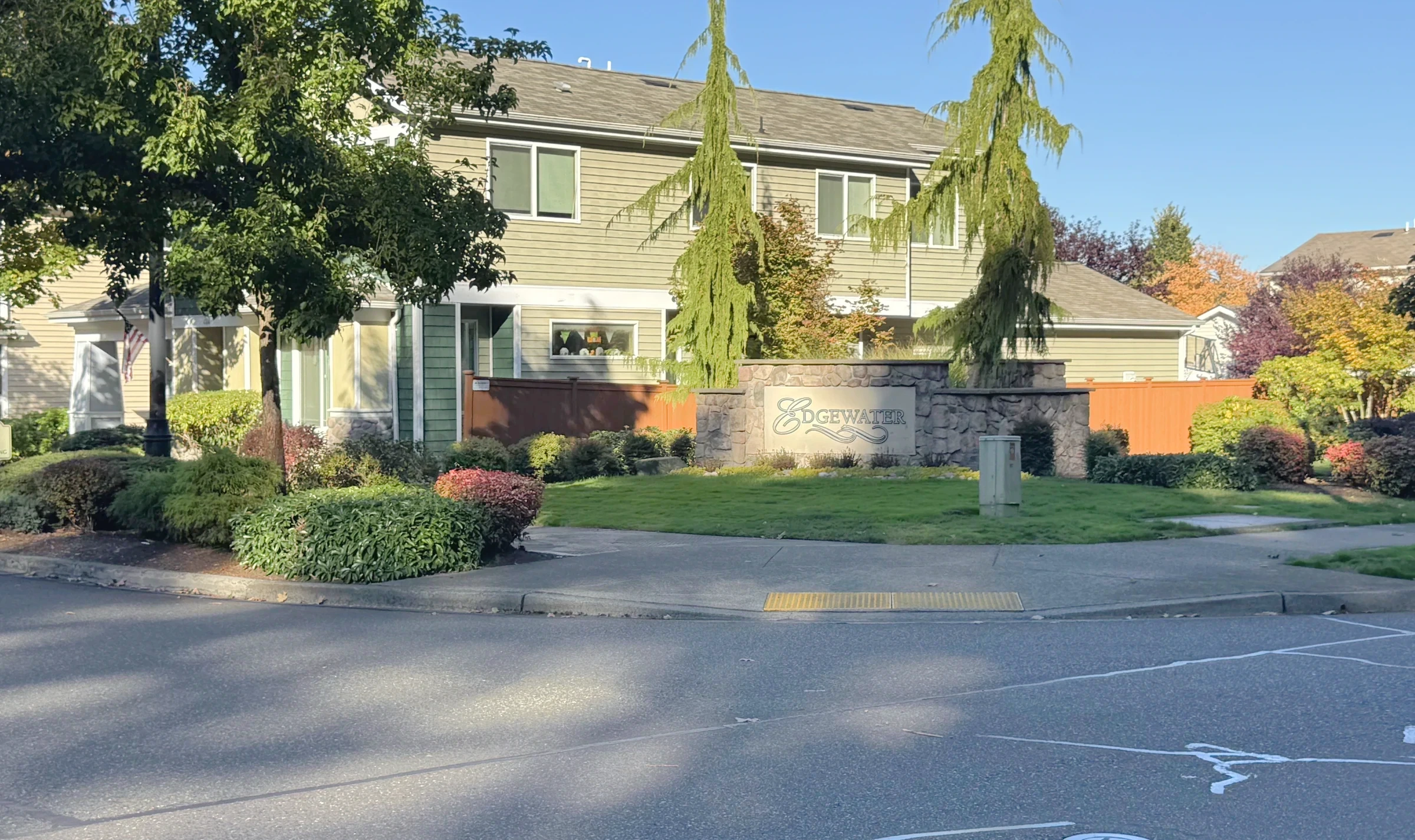
County parcel records identify Hawks Prairie · recorded divisions around TRADITIONS AVE NE, GREENVIEW DR NE, CASHMERE DR NE, EDGEWATER BLVD NE. Related record names and divisions remain separate until their original maps and governing documents establish the relationship.
Recorded construction samples:- HAWKS PRAIRIE: 2007–2008 · 4 year observations · 0.125-acre median residential lot
- HAWKS PRAIRIE PH 1: 2004–2021 · 945 year observations · 0.11-acre median residential lot
- HAWKS PRAIRIE PH 1 UNIT1: 2004 · 1 year observations · 0.34-acre median residential lot
2 additional recorded groups in the profile. Sampled buildings; not a complete buildout history.
Housing history, ownership & sources
- Construction history
- HAWKS PRAIRIE: 2007–2008 (4 year observations); HAWKS PRAIRIE PH 1: 2004–2021 (945 year observations); HAWKS PRAIRIE PH 1 UNIT1: 2004 (1 year observations). Additional groups appear in the table below. Separate recorded groups, not one combined buildout range.
- Housing & styles
- An architectural style is not inferred from a year-built field. Confirm the actual house and original plans.
- Homebuilder
- Original builder has not been established in the sources reviewed.
- Street examples
- TRADITIONS AVE NE · GREENVIEW DR NE · CASHMERE DR NE · EDGEWATER BLVD NE. Sample streets, not a boundary or a matched parcel list.
- Parcel-sample jurisdiction
- Lacey · Unincorporated Thurston County. This reflects the sampled parcels, not every property in the wider browsing region.
Recorded names & construction-year samples (5 record groups)
October 10, 2026 research snapshot. These are legal-description search groups, not a count of homes or certified plat boundaries. Divisions, phases and similarly named records remain separate. Year-built fields can include later replacement buildings and non-house property types.
Acreage is the median of positive lot-size observations below 100 acres coded RES in the research, not a measurement of every home lot. Samples can be incomplete or overlap; do not add them to calculate community totals. Confirm the actual parcel, original permit, additions and recorded map before relying on a date or size.
Evidence: parcel records. Development dates, association formation and individual home completion are separate facts. Research updated October 10, 2026.
Plat records
County parcel records identify Jaylee around HEPBURN ST NE. Related record names and divisions remain separate until their original maps and governing documents establish the relationship.
Recorded construction samples:- 2008–2016 · 142 year observations · 0.11-acre median residential lot
Sampled buildings; not a complete buildout history.
Housing history, ownership & sources
- Construction history
- 2008–2016 in 142 county year-built observations; median 2009.5. This is a recorded-building sample, not a complete original buildout chronology.
- Residential lot sample
- 0.11 acres median across 142 residential observations. Individual lots vary; this is not a subdivision-wide minimum or maximum.
- Housing & styles
- An architectural style is not inferred from a year-built field. Confirm the actual house and original plans.
- Homebuilder
- Original builder has not been established in the sources reviewed.
- Street examples
- HEPBURN ST NE. Sample streets, not a boundary or a matched parcel list.
- Parcel-sample jurisdiction
- Lacey. This reflects the sampled parcels, not every property in the wider browsing region.
Recorded names & construction-year samples (1 record groups)
October 10, 2026 research snapshot. These are legal-description search groups, not a count of homes or certified plat boundaries. Divisions, phases and similarly named records remain separate. Year-built fields can include later replacement buildings and non-house property types.
Acreage is the median of positive lot-size observations below 100 acres coded RES in the research, not a measurement of every home lot. Samples can be incomplete or overlap; do not add them to calculate community totals. Confirm the actual parcel, original permit, additions and recorded map before relying on a date or size.
Evidence: parcel records. Development dates, association formation and individual home completion are separate facts. Research updated October 10, 2026.
Subdivision
An age-restricted community with its own association identity.
Documented builder(s): Shea Homes; Century Communities for the Eagles Bluff collection
Other builders may also have contributed; not all home and phase records have been reconciled.
Shared rights & responsibilities: Confirm age restrictions, governing documents and amenities.
Housing history, ownership & sources
- Construction history
- A complete construction range is not yet established; verify the house in Assessor and original permit records.
- Housing & styles
- An architectural style is not inferred from a year-built field. Confirm the actual house and original plans.
- Homebuilder
- Shea Homes; Century Communities for the Eagles Bluff collection
- Ownership details
- Confirm age restrictions, governing documents and amenities.
Other builders may also have contributed; not all home and phase records have been reconciled. The documented attribution applies only to the community, offering or phase identified above.
Evidence: community documented. Development dates, association formation and individual home completion are separate facts.
Master plan
The master-plan umbrella contains multiple separately named subdivisions.
Housing history, ownership & sources
- Construction history
- A complete construction range is not yet established; verify the house in Assessor and original permit records.
- Housing & styles
- An architectural style is not inferred from a year-built field. Confirm the actual house and original plans.
- Homebuilder
- Documented builder participation is available at community or offering scope; the original contractor of each property remains unverified.
Evidence: community documented. Development dates, association formation and individual home completion are separate facts.
Plat records
County parcel records identify Nisqually Place around STEPHANIE LOOP NE. Related record names and divisions remain separate until their original maps and governing documents establish the relationship.
Recorded construction samples:- 2022–2024 · 46 year observations · 0.12-acre median residential lot
Sampled buildings; not a complete buildout history.
Documented builder: Soundbuilt Homes markets Release 1. Other releases and underlying recorded plat identity require separate confirmation.Source ↗
Other builders may also have contributed; not all home and phase records have been reconciled.
Housing history, ownership & sources
- Construction history
- 2022–2024 in 46 county year-built observations; median 2022.5. This is a recorded-building sample, not a complete original buildout chronology.
- Residential lot sample
- 0.12 acres median across 46 residential observations. Individual lots vary; this is not a subdivision-wide minimum or maximum.
- Street examples
- STEPHANIE LOOP NE. Sample streets, not a boundary or a matched parcel list.
- Parcel-sample jurisdiction
- Lacey. This reflects the sampled parcels, not every property in the wider browsing region.
- Homebuilder · documented offering
- Soundbuilt Homes markets Release 1. Other releases and underlying recorded plat identity require separate confirmation.Source ↗
- Housing & plans · documented offering
- Soundbuilt’s Release 1 advertised Aspen, Camden and Sterling plans for named homesites. Plans and builder attribution must be checked for the particular release and lot.Source ↗
Other builders may also have contributed; not all home and phase records have been reconciled. The documented attribution applies only to the community, offering or phase identified above.
Recorded names & construction-year samples (1 record groups)
October 10, 2026 research snapshot. These are legal-description search groups, not a count of homes or certified plat boundaries. Divisions, phases and similarly named records remain separate. Year-built fields can include later replacement buildings and non-house property types.
Acreage is the median of positive lot-size observations below 100 acres coded RES in the research, not a measurement of every home lot. Samples can be incomplete or overlap; do not add them to calculate community totals. Confirm the actual parcel, original permit, additions and recorded map before relying on a date or size.
Evidence: parcel records. Development dates, association formation and individual home completion are separate facts. Research updated October 10, 2026.
Plat records
County parcel records identify Raili May around BALI ST NE, MIA ST NE. Related record names and divisions remain separate until their original maps and governing documents establish the relationship.
Recorded construction samples:- 2006–2008 · 153 year observations · 0.12-acre median residential lot
Sampled buildings; not a complete buildout history.
Housing history, ownership & sources
- Construction history
- 2006–2008 in 153 county year-built observations; median 2007. This is a recorded-building sample, not a complete original buildout chronology.
- Residential lot sample
- 0.12 acres median across 153 residential observations. Individual lots vary; this is not a subdivision-wide minimum or maximum.
- Housing & styles
- An architectural style is not inferred from a year-built field. Confirm the actual house and original plans.
- Homebuilder
- Original builder has not been established in the sources reviewed.
- Street examples
- BALI ST NE · MIA ST NE. Sample streets, not a boundary or a matched parcel list.
- Parcel-sample jurisdiction
- Lacey. This reflects the sampled parcels, not every property in the wider browsing region.
Recorded names & construction-year samples (1 record groups)
October 10, 2026 research snapshot. These are legal-description search groups, not a count of homes or certified plat boundaries. Divisions, phases and similarly named records remain separate. Year-built fields can include later replacement buildings and non-house property types.
Acreage is the median of positive lot-size observations below 100 acres coded RES in the research, not a measurement of every home lot. Samples can be incomplete or overlap; do not add them to calculate community totals. Confirm the actual parcel, original permit, additions and recorded map before relying on a date or size.
Evidence: parcel records. Development dates, association formation and individual home completion are separate facts. Research updated October 10, 2026.
Plat records
County parcel records identify Whidbey Passage around HERRON ST NE. Related record names and divisions remain separate until their original maps and governing documents establish the relationship.
Recorded construction samples:- 2016–2018 · 107 year observations · 0.13-acre median residential lot
Sampled buildings; not a complete buildout history.
Housing history, ownership & sources
- Construction history
- 2016–2018 in 107 county year-built observations; median 2017. This is a recorded-building sample, not a complete original buildout chronology.
- Residential lot sample
- 0.13 acres median across 107 residential observations. Individual lots vary; this is not a subdivision-wide minimum or maximum.
- Housing & styles
- An architectural style is not inferred from a year-built field. Confirm the actual house and original plans.
- Homebuilder
- Original builder has not been established in the sources reviewed.
- Street examples
- HERRON ST NE. Sample streets, not a boundary or a matched parcel list.
- Parcel-sample jurisdiction
- Lacey. This reflects the sampled parcels, not every property in the wider browsing region.
Recorded names & construction-year samples (1 record groups)
October 10, 2026 research snapshot. These are legal-description search groups, not a count of homes or certified plat boundaries. Divisions, phases and similarly named records remain separate. Year-built fields can include later replacement buildings and non-house property types.
Acreage is the median of positive lot-size observations below 100 acres coded RES in the research, not a measurement of every home lot. Samples can be incomplete or overlap; do not add them to calculate community totals. Confirm the actual parcel, original permit, additions and recorded map before relying on a date or size.
Evidence: parcel records. Development dates, association formation and individual home completion are separate facts. Research updated October 10, 2026.
A named place is included even when photographs or a complete builder history are still being gathered. Exact home facts belong to its parcel, plat, permits and current association documents.