Skip to page content

Tumwater area · Region guide

Airport & Old Highway 99

The airport-area geography and separate residential developments south along Old Highway 99.

Explore 2 community profiles ↓
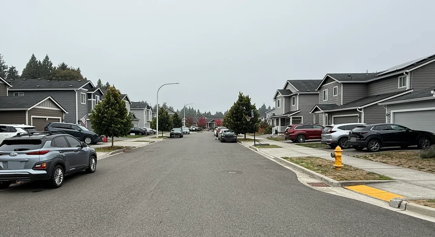
Residential street and sidewalk along Verbena Street SE
Verbena Street · Old Highway 99 area

The setting

The airport and Old Highway 99 approach, including newer communities south of the airport. Bush Prairie/Munn Lake east of it is a separate region.

The homes

Newer subdivisions and individual properties near employment and airport land.

Before you compare

City and urban-edge parcels can differ. Confirm jurisdiction, utilities and school assignment by address.

2 community profiles

Go one level closer

Neighborhoods within Airport & Old Highway 99

2 community profiles

Map & everyday geography

Get to know the streets

A closer look at the area.

Explore local streets and landmarks. Pins orient you to the area; shaded outlines are city-mapped associations, not the boundaries of this browsing region.

Streets: OpenStreetMap. Outlines: City of Olympia association data, retrieved September 19, 2026. Association outlines are not city limits or the full extent of every guide.View all neighborhoods →

Compare airport activity, land uses and actual routes. The Preserve and Bradbury have separate builder and association records.

Detailed neighborhood research, recorded names & construction history

Inside Airport & Old Highway 99

Neighborhoods, subdivisions & smaller places.

Compare each place on its own. Builder history, house age, style and ownership arrangements can change between neighboring streets. Recorded-name groups and dated development projects are labeled separately from established communities.

Subdivision

Bradbury

A separate Rob Rice community marketed at 8911 Old Highway 99.

Recorded construction samples:
  • BRADBURY DIV 2: 2021–2025 · 30 year observations · 0.11-acre median residential lot
  • BRADBURY DIV 3: 2020–2026 · 33 year observations · 0.12-acre median residential lot
  • BRADBURY DIVISION 1: 2020–2025 · 73 year observations · 0.1-acre median residential lot

Sampled buildings; not a complete buildout history.

Documented builder(s): Rob Rice Homes (marketed brand)

Other builders may also have contributed; not all home and phase records have been reconciled.

Housing detail: Published plans, 1,856–2,736 sq ft; verify phase and lot.

Housing history, ownership & sources
Construction history
BRADBURY DIV 2: 2021–2025 (30 year observations); BRADBURY DIV 3: 2020–2026 (33 year observations); BRADBURY DIVISION 1: 2020–2025 (73 year observations). Separate recorded groups, not one combined buildout range.
Housing & styles
Published plans, 1,856–2,736 sq ft; verify phase and lot.
Homebuilder
Rob Rice Homes (marketed brand)
Street examples
WYATT CT SE · WYATT LOOP SE. Sample streets, not a boundary or a matched parcel list.
Parcel-sample jurisdiction
Tumwater · Unincorporated Thurston County. This reflects the sampled parcels, not every property in the wider browsing region.
Homebuilder · documented offering
Rob Rice Homes markets/builds this named community. Applicable recorded divisions, developing legal entity and house-specific permits must be verified; this is not an attribution of every resale house.Source ↗

Other builders may also have contributed; not all home and phase records have been reconciled. The documented attribution applies only to the community, offering or phase identified above.

Recorded names & construction-year samples (3 record groups)

October 10, 2026 research snapshot. These are legal-description search groups, not a count of homes or certified plat boundaries. Divisions, phases and similarly named records remain separate. Year-built fields can include later replacement buildings and non-house property types.

Assessor sample by exact recorded name
Recorded nameYear-built sampleResidential lot sample
BRADBURY DIV 235 named parcel observations2021–202530 year observations · median 20240.11 acres median30 acreage observations
BRADBURY DIV 368 named parcel observations2020–202633 year observations · median 20240.12 acres median33 acreage observations
BRADBURY DIVISION 190 named parcel observations2020–202573 year observations · median 20210.1 acres median73 acreage observations

Acreage is the median of positive lot-size observations below 100 acres coded RES in the research, not a measurement of every home lot. Samples can be incomplete or overlap; do not add them to calculate community totals. Confirm the actual parcel, original permit, additions and recorded map before relying on a date or size.

Evidence: community documented. Development dates, association formation and individual home completion are separate facts. Research updated October 10, 2026.

Read the place profile →

Subdivision

The Preserve at Tumwater Place

A separate community south of the airport at the Old Highway 99/88th Avenue approach.

Construction context: Documented phase-two launch April 2019; earlier phase already occupied.

Documented builder(s): Century Communities for the documented phase

Other builders may also have contributed; not all home and phase records have been reconciled.

Housing detail: Two-story houses with Craftsman exteriors in the released phase.

Housing history, ownership & sources
Construction history
Documented phase-two launch April 2019; earlier phase already occupied.
Housing & styles
Two-story houses with Craftsman exteriors in the released phase.
Homebuilder
Century Communities for the documented phase
Street examples
VIOLA ST SE. Sample streets, not a boundary or a matched parcel list.
Parcel-sample jurisdiction
Tumwater. This reflects the sampled parcels, not every property in the wider browsing region.

Other builders may also have contributed; not all home and phase records have been reconciled. The documented attribution applies only to the community, offering or phase identified above.

Recorded names & construction-year samples (4 record groups)

October 10, 2026 research snapshot. These are legal-description search groups, not a count of homes or certified plat boundaries. Divisions, phases and similarly named records remain separate. Year-built fields can include later replacement buildings and non-house property types.

Assessor sample by exact recorded name
Recorded nameYear-built sampleResidential lot sample
PRESERVE AT TUMWATER PLACE DIV 4151 named parcel observations2021–2022140 year observations · median 20210.105 acres median140 acreage observations
PRESERVE AT TUMWATER PLACE, THE DIV 1 (PLAT ALTERATION)201 named parcel observations2014–2017188 year observations · median 20160.11 acres median190 acreage observations
THE PRESERVE AT TUMWATER PLACE DIV 236 named parcel observations2019–202034 year observations · median 20200.1 acres median34 acreage observations
THE PRESERVE AT TUMWATER PLACE DIVISION 3190 named parcel observations2020–2021183 year observations · median 20200.11 acres median183 acreage observations

Acreage is the median of positive lot-size observations below 100 acres coded RES in the research, not a measurement of every home lot. Samples can be incomplete or overlap; do not add them to calculate community totals. Confirm the actual parcel, original permit, additions and recorded map before relying on a date or size.

Evidence: history documented. Development dates, association formation and individual home completion are separate facts. Research updated October 10, 2026.

Read the place profile →

A named place is included even when photographs or a complete builder history are still being gathered. Exact home facts belong to its parcel, plat, permits and current association documents.

A closer look inside Airport & Old Highway 99

Start with the details that change from one place to another.

These local profiles surface a useful contrast in construction history, development or property responsibilities. Open the source notes before applying a community-level fact to a specific address.

History & construction

Bradbury

The county research keeps 3 recorded-name groups separate. “BRADBURY DIVISION 1” has 73 county records with a year built from 2020–2025, median 2021; sampled residential lots have a 0.1-acre median (73 observations); “BRADBURY DIV 3” has 33 county records with a year built from 2020–2026, median 2024; sampled residential lots have a 0.12-acre median (33 observations). These assessor samples help compare building eras, but do not establish the first or last home in a subdivision or the permit history of an individual address. 1 additional groups appear in the table below.

Open this place profile →
More local photographs & existing guides

Local landmarks & street-level context

Residential street and sidewalk along Verbena Street SE
Verbena Street in the south Tumwater/Old Highway 99 setting. The exact subdivision, builder and jurisdiction still belong to the property record.
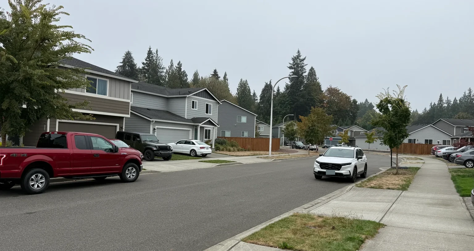
Detached homes along Verbena Street SE
A street-level look at this southern residential setting. Compare the lot and phase separately from Bush Prairie/Munn Lake.
Sources & how to read this research

Parcel-research snapshot: October 10, 2026. Page copy reviewed October 11, 2026. Regional labels are browsing choices; original records determine parcel facts. The directory is an expanding researched selection, not a certified complete inventory of every subdivision.

How the neighborhood records are interpreted →

← Browse all Tumwater regions · Compare two local guides ↗
Landmark photographs do not establish school attendance, public access or property rights.

Stay informed

Your local market, explained.

Get Kyle’s weekly brief, monthly housing report, or both.

Kyle Knows Oly

Your local edge.
Straight to your inbox.

Weekly local discoveries and buying tips. Monthly Thurston County housing numbers, explained by Kyle Murphy.

Preview the latest market report →

Add a phone number or a note (optional)
Email preferences

By submitting, you ask Kyle to email your selected updates. Unsubscribe at any time. Privacy